Maps can be more than geography; they can be works of art. Medieval and early Renaissance cartographers commonly showed the known, habitable world in mappae mundi—Latin for “cloth of the world.” Mapmakers combined classical and biblical sources, blending history and geography, to create these beautiful documents.
The map form comes from an ancient Greek cartographic tradition. The known world, or oikoumene, was depicted as a flat disk surrounded by the ocean, though the Greeks and their intellectual successors knew the world was round.
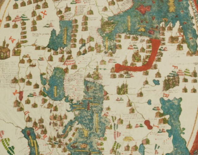
Venetian cartographer Giovanni Leardo’s mappa mundi, most likely produced in 1452 or 1453, has three parts: a central disk containing a map of the world, concentric rings of inscriptions, and a block-text inscription. The map itself is further divided into three parts depicting the three known continents. Asia fills the upper half of the disk, while the lower half is split between Europe to the left and Africa to the right. Jerusalem sits at the center of the map, with Terrestrial Paradise, or Eden, at the top.
Each feature is carefully labeled with an inscription in Leardo’s Venetian dialect. In the north lies a “desert uninhabited due to cold,” and in the south, a “desert uninhabited due to heat.” In the lower right the Sahara is labeled “Sandy Sea.” Small vignettes of castles, walled towns, and churches—each symbolizing various cities, kingdoms, or regions—dot the map.
An unusual calendar formed by a series of 10 concentric rings makes a border. The innermost ring gives the dates of Easter, from April 1, 1453, to April 10, 1547. The second ring lists the day, year, and time when the sun enters each sign of the zodiac. The remaining rings describe phases of the Moon, saints’ days, and religious festivals.
Mappae mundi are traditionally rife with biblical imagery. In each corner Leardo drew the symbol for one of the Four Evangelists. Clockwise from the upper left are an eagle for St. John, a lion for St. Mark, a bull for St. Luke, and an angel for St. Matthew. Cartographers also often emphasized cities or events significant to the Old Testament. Here, Leardo depicts Mt. Sinai, Noah’s ark on top of Mt. Ararat, and an elongated Jordan River.
In 1906 the American Geographical Society acquired the largest of three surviving maps by Leardo. Twenty-two years later they produced full-sized, color facsimiles, one of which found its way into Donald and Mildred Othmer’s collection of antique maps. The Othmers were avid travelers who circled the globe 13 times in their years together. This facsimile is part of the art collection they left to the Chemical Heritage Foundation.